Politics and Elections

Hurricane Iota is the 30th storm this season and it’s already Cat 5

Author: Vibor Cipan Published on: November 16, 2020, and filed under Climate and weather
  • Iota is the 30th named storm in this 2020 Atlantic hurricane season
  • Vever before has such a strong hurricane been recorded so late in the year in the Atlantic (Cat. 5)
  • The central pressure is falling and is at 917hPa
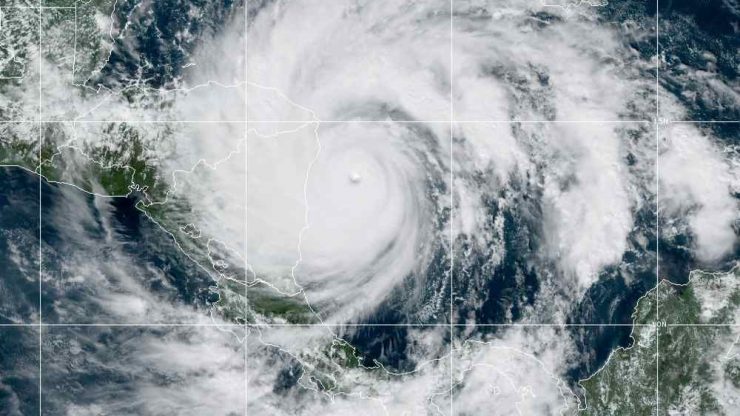
View of Hurricane Iota as seen by the GOES satellite. Courtesy of NASA / NOOA View of Hurricane Iota as seen by the GOES satellite. Courtesy of NASA / NOOA

The 2020 Atlantic hurricane season continues to break records. In the Gulf of Mexico, first, the storm named Iota was formed. Now it is already a Category 5 destructive hurricane headed towards Nicaragua!

A few days ago, we wrote that Theta broke the 2005 record by becoming the 29th named storm. However, this year’s hurricane season in the Atlantic has already produced a new storm called – Iota.

At the time of writing this post, Iota is a hurricane of the 5th, the strongest category. This means winds reach speeds of over 255 kilometers per hour.
Iota is also the strongest hurricane in the history of measurement that appeared and formed so late on the Atlantic. The current air pressure is only 917hPa – the lowest recorded hurricane-related air pressure so late in the season.

Iota is moving towards Nicaragua. After coming over the land and entering Honduras, it will continue to weaken and cross El Salvador into the Pacific Ocean as a tropical depression.
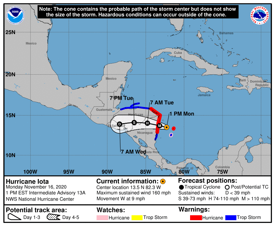
Hurricane Iota is expected to move in the coming days

The speed of intensification and significance of Iota may be well illustrated by the fact that in the last 169 years, before 2020, only 8 storms had such a substantial increase in intensity (increase in wind speed by 160km / h within 36 hours). These were Labor Day Hurricane (1935), Camille (1969), Andrew (1992), Rita (2005), Wilma (2005), Felix (2007), Matthew (2016), and Maria (2017).
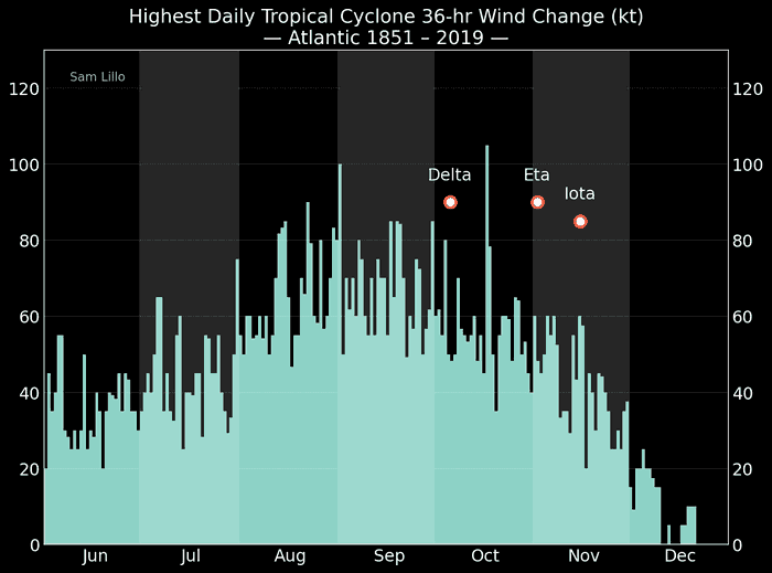
A clear picture of the last three storms and the speed of their intensification in relation to historical data. Courtesy: Sam Lillo (@splillo)

This year we have already had three such storms, and all three in the last 3 months: Delta, Eta, and Iota.

For perspective, we repeat – in the past 169 years (1850-2019), we have had eight hurricanes with such an increase in intensity. In 2020, in just the previous 3 months, we had 3 of them!

As we wrote in an earlier article, although the number of hurricanes alone is not a consequence of climate change, individual storms’ intensification is. This should be added to the increased danger due to floods and tidal waves caused by hurricanes, especially within the context of rising sea levels.


Author avatar

ABOUT THE AUTHOR

Vibor Cipan

With over 15 years of professional work in technology, Vibor Cipan is a recognized leader in this field. His contributions at Microsoft, where he earned the prestigious MVP title, set the stage for his roles as CEO and Co-Founder of UX Passion, and later on, Point Jupiter, a data-informed agency. There, he led teams that shaped services for over 400 million users globally. His work spans UX design and software development, driving significant contributions in both fields.

Currently immersed in the generative AI sector, Cipan is taking part in projects revolutionizing software development and user engagement. His expertise extends into data viz, analytics and Open Source Intelligence (OSINT), where he actively develops proofs of concept and explores AI's role in shaping societal dynamics and national security.

An accomplished author and speaker, Vibor continues to share his insights at international venues, advocating for innovation and a richer understanding of technology's impact on society.

You can follow him on LinkedIn or Twitter/X as @viborc.

Don't stop reading

Older articles